
Fort Bragg topographic map
Interactive map
Click on the map to display elevation.
About this map
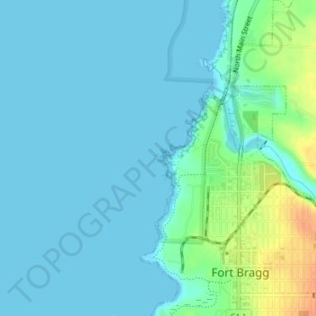
Name: Fort Bragg topographic map, elevation, terrain.
Location: Fort Bragg, Mendocino County, California, United States (39.45312 -123.81527 39.45373 -123.81428)
Average elevation: 8 m
Minimum elevation: -2 m
Maximum elevation: 39 m
Fort Bragg is a city along the Pacific Coast of California along Shoreline Highway in Mendocino County. The city is 24 miles (39 km) west of Willits, at an elevation of 85 feet (26 m). Its population was 6,983 at the 2020 census.
Other topographic maps
Click on a map to view its topography, its elevation and its terrain.
Pine Grove
United States > California > Mendocino County
Pine Grove, Mendocino County, California, 95460, United States
Average elevation: 40 m
The Oaks
United States > California > Mendocino County
The Oaks, Mendocino County, California, United States
Average elevation: 426 m