
Make a donation
Gear up for your next adventure:
As an Amazon Associate, this site earns from qualifying purchases at no extra cost to you.
Bellmead topographic map
Click on the map to display elevation.
Make a donation
Gear up for your next adventure:
As an Amazon Associate, this site earns from qualifying purchases at no extra cost to you.
About this map
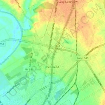
Name: Bellmead topographic map, elevation, terrain.
Location: Bellmead, McLennan County, Texas, 76705, United States (31.57291 -97.12324 31.63103 -97.06051)
Average elevation: 135 m
Minimum elevation: 119 m
Maximum elevation: 153 m
Make a donation
Gear up for your next adventure:
As an Amazon Associate, this site earns from qualifying purchases at no extra cost to you.
Other topographic maps
Click on a map to view its topography, its elevation and its terrain.
Make a donation
Gear up for your next adventure:
As an Amazon Associate, this site earns from qualifying purchases at no extra cost to you.
Make a donation
Gear up for your next adventure:
As an Amazon Associate, this site earns from qualifying purchases at no extra cost to you.
Northcrest
United States > Texas > McLennan County > Lacy-Lakeview > Northcrest
Average elevation: 149 m