
Make a donation
Gear up for your next adventure:
As an Amazon Associate, this site earns from qualifying purchases at no extra cost to you.
Vlieghuis topographic map
Click on the map to display elevation.
Make a donation
Gear up for your next adventure:
As an Amazon Associate, this site earns from qualifying purchases at no extra cost to you.
About this map
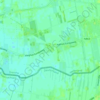
Name: Vlieghuis topographic map, elevation, terrain.
Location: Vlieghuis, Coevorden, Drenthe, Nederland, 7742 PR, Nederland (52.63886 6.81771 52.67886 6.85771)
Average elevation: 12 m
Minimum elevation: 8 m
Maximum elevation: 16 m
Make a donation
Gear up for your next adventure:
As an Amazon Associate, this site earns from qualifying purchases at no extra cost to you.
Other topographic maps
Click on a map to view its topography, its elevation and its terrain.
Make a donation
Gear up for your next adventure:
As an Amazon Associate, this site earns from qualifying purchases at no extra cost to you.
Make a donation
Gear up for your next adventure:
As an Amazon Associate, this site earns from qualifying purchases at no extra cost to you.
Zwinderen
Nederland > Drenthe > Coevorden
Bronnen vermelden: in Suinre (1217), de Swinre (1276), Swijnre (1295), Zwynderen (1527), Swinder (1811-13). De plaatsnaam is samengesteld uit : a) swin, zwin = waterloop, geul, kreek (afgeleid van swinan = verdwijnen, verzwinden) en horne (= hoek) of b) swin en heri, hara = met bos begroeide hoogte. De…
Average elevation: 14 m
Make a donation
Gear up for your next adventure:
As an Amazon Associate, this site earns from qualifying purchases at no extra cost to you.
Schoonoord
Nederland > Drenthe > Coevorden
Schoonoord is rond 1850 ontstaan op een zandige hoogte aan de rand van het Odoornerveen. Kort daarna werd het Oranjekanaal gegraven. Daarlangs, en aan de haaks erop gelegen weg Coevorden - Assen, kwam een zich snel uitbreidend lintdorp van in eerste instantie vooral plaggenhutten tot stand. In 1856 telde het…
Average elevation: 19 m
Make a donation
Gear up for your next adventure:
As an Amazon Associate, this site earns from qualifying purchases at no extra cost to you.