
Hillvue topographic map
Interactive map
Click on the map to display elevation.
About this map
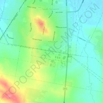
Name: Hillvue topographic map, elevation, terrain.
Average elevation: 407 m
Minimum elevation: 379 m
Maximum elevation: 462 m
Other topographic maps
Click on a map to view its topography, its elevation and its terrain.
Peel River
Australia > New South Wales > Tamworth
Peel River, Tamworth, Tamworth Regional Council, New South Wales, Australia
Average elevation: 593 m
Kingswood Park
Australia > New South Wales > Tamworth
Kingswood Park, Kingswood, Tamworth, Tamworth Regional Council, New South Wales, 2340, Australia
Average elevation: 421 m
Westdale
Australia > New South Wales > Tamworth
Westdale, Tamworth, Tamworth Regional Council, New South Wales, 2340, Australia
Average elevation: 402 m