Geolocate

Homlung topographic map

Click on the map to display elevation.

About this map

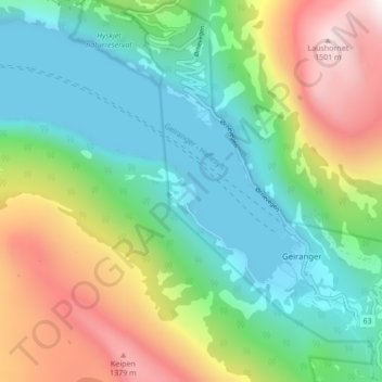
Name: Homlung topographic map, elevation, terrain.

Location: Homlung, Geiranger, Stranda, Møre og Romsdal, 6216, Norway (62.08764 7.16043 62.12764 7.20043)

Average elevation: 513 m

Minimum elevation: -7 m

Maximum elevation: 1,551 m

Other topographic maps

Click on a map to view its topography, its elevation and its terrain.

Geirangerfjord

Norway > Møre og Romsdal > Geiranger

Average elevation: 670 m

Geirangerfjord

Norway > Møre og Romsdal > Geiranger

Average elevation: 812 m

Geirangerfjord

Norway > Møre og Romsdal > Geiranger

Average elevation: 812 m

Gear up for your next adventure:

🩹Blister Prevention Tape - Apply to friction points before they become painful sores
🔦Powerful LED Headlamps - Hands-free lighting for night navigation and setting up camp after dark
🥾Heavy Duty Hiking Boots - Ankle-supporting boots for carrying heavy packs on steep contours
🧊Insulated Stainless Steel Flasks - Keep water cold for 24 hours in the heat or coffee hot in the cold
Outdoor Coffee Makers - Enjoy quality coffee at the summit of your favorite peak

As an Amazon Associate, this site earns from qualifying purchases at no extra cost to you.