
Town of Marcy topographic map
Interactive map
Click on the map to display elevation.
About this map
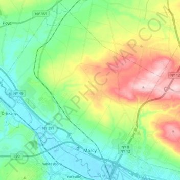
Name: Town of Marcy topographic map, elevation, terrain.
Average elevation: 207 m
Minimum elevation: 119 m
Maximum elevation: 393 m
Other topographic maps
Click on a map to view its topography, its elevation and its terrain.
Village of Clinton
United States > New York > Oneida County > Town of Kirkland
Village of Clinton, Town of Kirkland, Whitestown, Oneida County, New York, United States
Average elevation: 191 m
Village of Boonville
United States > New York > Oneida County
Village of Boonville, Town of Boonville, Oneida County, New York, 13309, United States
Average elevation: 354 m
Eaton Hill
United States > New York > Oneida County > Town of Vernon
Eaton Hill, Town of Vernon, Oneida County, New York, 13477, United States
Average elevation: 342 m
Village of Yorkville
United States > New York > Oneida County > Village of Yorkville
Village of Yorkville, Town of Whitestown, Oneida County, New York, United States
Average elevation: 138 m