
Laguna Beach topographic map
Interactive map
Click on the map to display elevation.
About this map
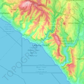
Name: Laguna Beach topographic map, elevation, terrain.
Average elevation: 62 m
Minimum elevation: -1 m
Maximum elevation: 353 m
The land in and around Laguna Beach rises quickly from the shoreline into the hills and canyons of the San Joaquin Hills. The town's highest point, at an elevation of 1,007 feet (307 m), is Temple Hill in the Top of the World neighborhood. Because of its hilly topography and surrounding parklands, few roads run into or out of town; only the Coast Highway connecting to Newport Beach to the northwest and to Dana Point to the south, and State Route 133 crossing the hills in a northeastern direction through Laguna Canyon. Parts of Laguna Beach border the Aliso/Wood Canyons Regional Park.
Other topographic maps
Click on a map to view its topography, its elevation and its terrain.
Lake Forest
United States > California > Orange County
Lake Forest, Orange County, California, United States
Average elevation: 193 m
South Coast
United States > California > Orange County > Santa Ana
South Coast, Santa Ana, Orange County, CAL Fire Southern Region, California, United States
Average elevation: 13 m
Los Alamitos
United States > California > Orange County
Los Alamitos, Orange County, CAL Fire Southern Region, California, 90702, United States
Average elevation: 8 m
Brea
United States > California > Orange County
Brea, Orange County, CAL Fire Southern Region, California, 92821, United States
Average elevation: 163 m
Aliso Viejo
United States > California > Orange County
Aliso Viejo, Orange County, CAL Fire Southern Region, California, 92656, United States
Average elevation: 127 m
Huntington Beach
United States > California > Orange County
Huntington Beach, Orange County, California, United States
Average elevation: 7 m
Fullerton
United States > California > Orange County
Fullerton, Orange County, CAL Fire Southern Region, California, United States
Average elevation: 79 m
Leisure World
United States > California > Orange County > Seal Beach > Leisure World
Leisure World, Seal Beach, Orange County, California, 90744, United States
Average elevation: 6 m
Santa Ana
United States > California > Orange County > Santa Ana
Santa Ana, Orange County, California, 82706, United States
Average elevation: 83 m
Anaheim
United States > California > Orange County > Anaheim
Anaheim, Orange County, California, 92805, United States
Average elevation: 98 m
Irvine
United States > California > Orange County
Irvine, Orange County, California, United States
Average elevation: 66 m
Newport Beach
United States > California > Orange County
Newport Beach, Orange County, CAL Fire Southern Region, California, United States
Average elevation: 14 m