
Азат topographic map
Interactive map
Click on the map to display elevation.
About this map
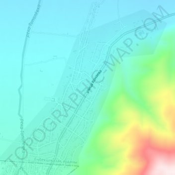
Name: Азат topographic map, elevation, terrain.
Location: Азат, Енбекшиказахский район, Алматинская область, Казахстан (43.34207 77.24924 43.36627 77.28516)
Average elevation: 864 m
Minimum elevation: 765 m
Maximum elevation: 1,325 m
Other topographic maps
Click on a map to view its topography, its elevation and its terrain.
Тополёвка
Казахстан > Алматинская область > Енбекшиказахский район > Азат
Тополёвка, Азат, Енбекшиказахский район, Алматинская область, Казахстан
Average elevation: 899 m