
Make a donation
Gear up for your next adventure:
As an Amazon Associate, this site earns from qualifying purchases at no extra cost to you.
Zapallar topographic map
Click on the map to display elevation.
Make a donation
Gear up for your next adventure:
As an Amazon Associate, this site earns from qualifying purchases at no extra cost to you.
About this map
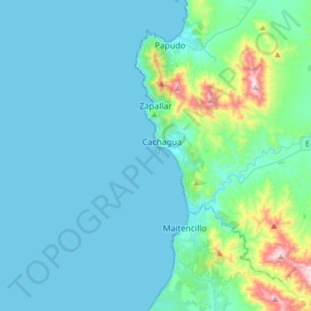
Name: Zapallar topographic map, elevation, terrain.
Location: Zapallar, Provincia de Petorca, Valparaiso Region, Chile (-32.68362 -71.47674 -32.49643 -71.20155)
Average elevation: 95 m
Minimum elevation: 0 m
Maximum elevation: 771 m
Make a donation
Gear up for your next adventure:
As an Amazon Associate, this site earns from qualifying purchases at no extra cost to you.
Other topographic maps
Click on a map to view its topography, its elevation and its terrain.
Punta Pite
Chile > Valparaiso Region > Provincia de Petorca > Zapallar > Punta Pite Norte
Average elevation: 35 m
Las Terrazas
Chile > Valparaiso Region > Provincia de Petorca > Petorca > Hierro Viejo
Average elevation: 615 m
Punta Pite
Chile > Valparaiso Region > Provincia de Petorca > Zapallar > Punta Pite Norte
Average elevation: 35 m
Make a donation
Gear up for your next adventure:
As an Amazon Associate, this site earns from qualifying purchases at no extra cost to you.
Punta Pite
Chile > Valparaiso Region > Provincia de Petorca > Zapallar > Punta Pite Norte
Average elevation: 35 m