
Make a donation
Gear up for your next adventure:
As an Amazon Associate, this site earns from qualifying purchases at no extra cost to you.
Nazas topographic map
Click on the map to display elevation.
Make a donation
Gear up for your next adventure:
As an Amazon Associate, this site earns from qualifying purchases at no extra cost to you.
About this map
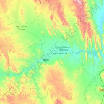
Name: Nazas topographic map, elevation, terrain.
Location: Nazas, Durango, Mexico (24.95566 -104.38345 25.58629 -103.77797)
Average elevation: 1,589 m
Minimum elevation: 1,162 m
Maximum elevation: 2,629 m
Make a donation
Gear up for your next adventure:
As an Amazon Associate, this site earns from qualifying purchases at no extra cost to you.
Other topographic maps
Click on a map to view its topography, its elevation and its terrain.
Make a donation
Gear up for your next adventure:
As an Amazon Associate, this site earns from qualifying purchases at no extra cost to you.
Cienega de Nuestra Señora
Mexico > Durango > Santiago Papasquiaro > Cienega de Nuestra Señora
Average elevation: 2,591 m
Make a donation
Gear up for your next adventure:
As an Amazon Associate, this site earns from qualifying purchases at no extra cost to you.