Geolocate

Trowbridge topographic map

Click on the map to display elevation.

About this map

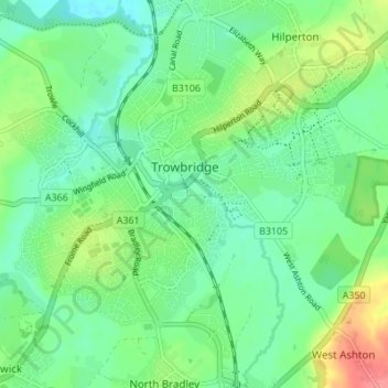
Name: Trowbridge topographic map, elevation, terrain.

Location: Trowbridge, Wiltshire, England, United Kingdom (51.29480 -2.23556 51.33752 -2.17347)

Average elevation: 47 m

Minimum elevation: 25 m

Maximum elevation: 96 m

Other topographic maps

Click on a map to view its topography, its elevation and its terrain.

Quidhampton

United Kingdom > England > Wiltshire

Average elevation: 71 m

West Amesbury

United Kingdom > England > Wiltshire

Average elevation: 90 m

Gear up for your next adventure:

👄SPF Lip Balm - Prevent sun and wind-burnt lips on mountain ridges
🧥Insulated Down Jackets - High warmth-to-weight ratio for cold nights in the high country
🦶Orthotic Hiking Insoles - Extra arch support for long-distance topographic treks
🧰Survival Kits - Essential survival gear
🧦Hiking Socks - Comfortable socks for long hikes

As an Amazon Associate, this site earns from qualifying purchases at no extra cost to you.