
Make a donation
Gear up for your next adventure:
As an Amazon Associate, this site earns from qualifying purchases at no extra cost to you.
Chez Bardet topographic map
Click on the map to display elevation.
Make a donation
Gear up for your next adventure:
As an Amazon Associate, this site earns from qualifying purchases at no extra cost to you.
About this map
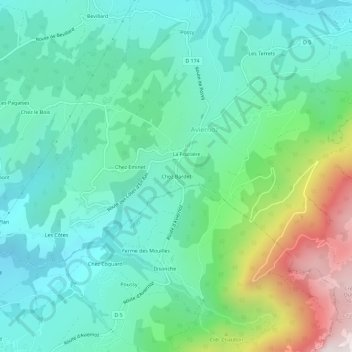
Name: Chez Bardet topographic map, elevation, terrain.
Average elevation: 857 m
Minimum elevation: 578 m
Maximum elevation: 1,671 m
Make a donation
Gear up for your next adventure:
As an Amazon Associate, this site earns from qualifying purchases at no extra cost to you.
Other topographic maps
Click on a map to view its topography, its elevation and its terrain.
Saint-Martin-Bellevue
France > Auvergne-Rhône-Alpes > Haute-Savoie > Fillière
Le point le plus haut de la commune se situe au nord de celle-ci, au dessus du lieu-dit « les chappaliers ». Aisément accessible à pied depuis la route des bois boccards, et repérable de loin par la présence d’une antenne-relais, il se situe à plus de 760m d’altitude.
Average elevation: 626 m
Évires
France > Auvergne-Rhône-Alpes > Haute-Savoie > Fillière
Évires est une commune classée en zone montagne avec une altitude moyenne de 774 m (min. 593 m, max. 955 m).
Average elevation: 829 m
Make a donation
Gear up for your next adventure:
As an Amazon Associate, this site earns from qualifying purchases at no extra cost to you.