
新竹市 topographic map
Interactive map
Click on the map to display elevation.
About this map
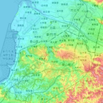
Name: 新竹市 topographic map, elevation, terrain.
Location: 新竹市, Provincia de Taiwán, Taiwán (24.71257 120.87942 24.85321 121.03354)
Average elevation: 47 m
Minimum elevation: -2 m
Maximum elevation: 196 m
Other topographic maps
Click on a map to view its topography, its elevation and its terrain.
埤麻里
Taiwán > Provincia de Taiwán > 埤麻
埤麻里, 埤麻, Condado de Yunlin, Provincia de Taiwán, 63201, Taiwán
Average elevation: 27 m