
Melveren topographic map
Interactive map
Click on the map to display elevation.
About this map
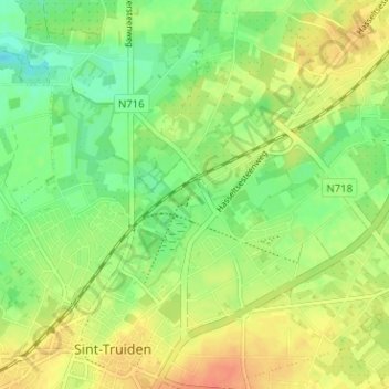
Name: Melveren topographic map, elevation, terrain.
Average elevation: 46 m
Minimum elevation: 26 m
Maximum elevation: 66 m
Other topographic maps
Click on a map to view its topography, its elevation and its terrain.
Zepperen
België > Limburg > Hasselt > Sint-Truiden
Zepperen, Sint-Truiden, Hasselt, Limburg, Vlaanderen, België
Average elevation: 52 m
Sint-Truiden
België > Limburg > Hasselt > Sint-Truiden
Sint-Truiden, Hasselt, Limburg, Vlaanderen, België
Average elevation: 54 m