
Haut-Katanga topographic map
Interactive map
Click on the map to display elevation.
About this map
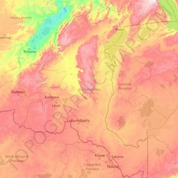
Name: Haut-Katanga topographic map, elevation, terrain.
Location: Haut-Katanga, Democratic Republic of the Congo (-13.45904 25.48682 -7.58031 29.81479)
Average elevation: 1,174 m
Minimum elevation: 558 m
Maximum elevation: 2,361 m
Other topographic maps
Click on a map to view its topography, its elevation and its terrain.
Kasanda
Democratic Republic of the Congo > Haut-Katanga > Ville de Lubumbashi > Matoleo
Kasanda, Matoleo, Ruashi, Ville de Lubumbashi, Haut-Katanga, Democratic Republic of the Congo
Average elevation: 1,303 m
Musumba
Democratic Republic of the Congo > Haut-Katanga > Musumba
Musumba, Katuba, Ville de Lubumbashi, Haut-Katanga, Democratic Republic of the Congo
Average elevation: 1,207 m