Geolocate

Patching topographic map

Click on the map to display elevation.

About this map

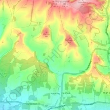
Name: Patching topographic map, elevation, terrain.

Location: Patching, Arun, West Sussex, England, United Kingdom (50.83693 -0.47755 50.89689 -0.44411)

Average elevation: 86 m

Minimum elevation: 4 m

Maximum elevation: 203 m

Other topographic maps

Click on a map to view its topography, its elevation and its terrain.

Fontwell

United Kingdom > England > West Sussex > Arun

Average elevation: 31 m

Eastergate

United Kingdom > England > West Sussex > Arun

Average elevation: 12 m

Barnham

United Kingdom > England > West Sussex > Arun

Average elevation: 6 m

Shripney

United Kingdom > England > West Sussex > Arun

Average elevation: 3 m

Eastergate

United Kingdom > England > West Sussex > Arun

Average elevation: 12 m

Wick

United Kingdom > England > West Sussex > Arun > Littlehampton > Lyminster

Average elevation: 3 m

Bognor Regis

United Kingdom > England > West Sussex > Arun > Nyetimber

Average elevation: 2 m

Lidsey Rife

United Kingdom > England > West Sussex > Arun > Felpham

Average elevation: 3 m

Elmer

United Kingdom > England > West Sussex > Arun

Average elevation: 2 m

Nyetimber

United Kingdom > England > West Sussex > Arun

Average elevation: 3 m

North Bersted

United Kingdom > England > West Sussex > Arun

Average elevation: 3 m

Binsted

United Kingdom > England > West Sussex > Arun > Walberton

Average elevation: 23 m

Gear up for your next adventure:

🔦Headlamps - Hands-free lighting for hiking
🧺Fast-Dry Microfiber Towels - Large towels that pack down to the size of an orange
🚗Car Camping Gear - Equipment for vehicle camping
📣High-Decibel Survival Whistles - Signaling tool for rescue that carries much further than a human voice
🥾Hiking Gaiters - Leg protection for trails

As an Amazon Associate, this site earns from qualifying purchases at no extra cost to you.