
Le Mas topographic map
Interactive map
Click on the map to display elevation.
About this map
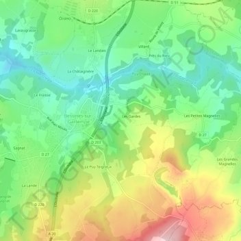
Name: Le Mas topographic map, elevation, terrain.
Average elevation: 349 m
Minimum elevation: 254 m
Maximum elevation: 500 m
Other topographic maps
Click on a map to view its topography, its elevation and its terrain.
La Croix du Breuil
France > Nouvelle-Aquitaine > Haute-Vienne > Bessines-sur-Gartempe
La Croix du Breuil, Bessines-sur-Gartempe, Bellac, Haute-Vienne, Nouvelle-Aquitaine, France métropolitaine, 87250, France
Average elevation: 326 m
Le Fraisse
France > Nouvelle-Aquitaine > Haute-Vienne > Bessines-sur-Gartempe
Le Fraisse, Bessines-sur-Gartempe, Bellac, Haute-Vienne, Nouvelle-Aquitaine, France métropolitaine, 87250, France
Average elevation: 330 m
La Lande
France > Nouvelle-Aquitaine > Haute-Vienne > Bessines-sur-Gartempe
La Lande, Bessines-sur-Gartempe, Bellac, Haute-Vienne, Nouvelle-Aquitaine, France métropolitaine, 87250, France
Average elevation: 364 m