
Make a donation
Gear up for your next adventure:
As an Amazon Associate, this site earns from qualifying purchases at no extra cost to you.
Schochen topographic map
Click on the map to display elevation.
Make a donation
Gear up for your next adventure:
As an Amazon Associate, this site earns from qualifying purchases at no extra cost to you.
Schochen
Die Schartenhöhe des Schochens beträgt mindestens 60 Meter, seine Dominanz 800 Meter, wobei jeweils der Lachenkopf Referenzberg ist.
Make a donation
Gear up for your next adventure:
As an Amazon Associate, this site earns from qualifying purchases at no extra cost to you.
About this map
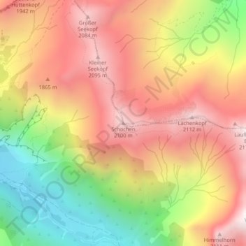
Name: Schochen topographic map, elevation, terrain.
Average elevation: 1,643 m
Minimum elevation: 1,019 m
Maximum elevation: 2,147 m
Make a donation
Gear up for your next adventure:
As an Amazon Associate, this site earns from qualifying purchases at no extra cost to you.
Other topographic maps
Click on a map to view its topography, its elevation and its terrain.
Schlappolt
Deutschland > Bayern > Landkreis Oberallgäu > Oberstdorf
Das 163,43 ha große Gebiet mit der Nr. NSG-00298.01 wurde im Jahr 1986 unter Naturschutz gestellt. Es ist in Bayern der einzige Flyschbereich, der nahezu die alpine Höhenstufe erreicht.
Average elevation: 1,587 m