Geolocate
👉 Easily get elevation data in JSON, GeoTIFF and KML formats using Elevation API
Thank you for supporting this site ❤️
Make a donation

Gear up for your next adventure:

As an Amazon Associate, this site earns from qualifying purchases at no extra cost to you.

Matacon topographic map

Click on the map to display elevation.

About this map

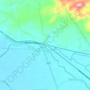
Name: Matacon topographic map, elevation, terrain.

Location: Matacon, Polangui, Albay, Bicol Region, 4506, Philippines (13.30532 123.41343 13.34532 123.45343)

Average elevation: 36 m

Minimum elevation: 6 m

Maximum elevation: 181 m

Gear up for your next adventure:

🛌Sleeping Bags - Sleeping bags for outdoor camping
🧥Packable Rain Jackets - Breathable waterproof layers for unpredictable mountain weather
🚴Cycling Backpacks - Backpacks for cyclists
🍶Collapsible Water Bottles - Save space in your pack as you consume your water supply
🧣Merino Neck Gaiters - Versatile headwear for warmth, sun protection, or dust filtering

As an Amazon Associate, this site earns from qualifying purchases at no extra cost to you.