
Quintas topographic map
Interactive map
Click on the map to display elevation.
About this map
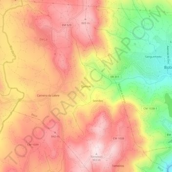
Name: Quintas topographic map, elevation, terrain.
Location: Quintas, Beça, Boticas, Vila Real, 5460-322, Portugal (41.66385 -7.71110 41.70385 -7.67110)
Average elevation: 723 m
Minimum elevation: 456 m
Maximum elevation: 895 m
Other topographic maps
Click on a map to view its topography, its elevation and its terrain.
Vilarinho da Mó
Portugal > Vila Real > Boticas > Beça
Vilarinho da Mó, Beça, Boticas, Vila Real, Portugal
Average elevation: 865 m
Carreira da Lebre
Portugal > Vila Real > Boticas > Beça
Carreira da Lebre, Beça, Boticas, Vila Real, 5460-322, Portugal
Average elevation: 766 m