
Real topographic map
Interactive map
Click on the map to display elevation.
About this map
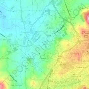
Name: Real topographic map, elevation, terrain.
Location: Real, Braga, 4700-282, Portugal (41.54007 -8.45893 41.58007 -8.41893)
Average elevation: 117 m
Minimum elevation: 38 m
Maximum elevation: 287 m
Other topographic maps
Click on a map to view its topography, its elevation and its terrain.
Santa Lucrécia de Algeriz e Navarra
Santa Lucrécia de Algeriz e Navarra, Braga, Portugal
Average elevation: 149 m