Geolocate

Dagatan topographic map

Click on the map to display elevation.

About this map

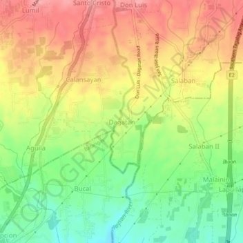
Name: Dagatan topographic map, elevation, terrain.

Location: Dagatan, San Jose, Batangas, Calabarzon, 4227, Philippines (13.83069 121.08278 13.87069 121.12278)

Average elevation: 174 m

Minimum elevation: 122 m

Maximum elevation: 222 m

Other topographic maps

Click on a map to view its topography, its elevation and its terrain.

Santo Cristo

Philippines > Batangas > San Jose

Average elevation: 221 m

Aguila

Philippines > Batangas > San Jose

Average elevation: 168 m

Calansayan

Philippines > Batangas > San Jose > Dagatan

Average elevation: 188 m

Gear up for your next adventure:

🎒40L Day Hiking Backpacks - Comfortable packs with hydration support for long days exploring topographic peaks
🥤Outdoor Water Bottles - Reusable bottles for outdoor activities
🎒Hiking Backpacks - Backpacks designed for hiking and trekking
🦟Insect Repellent - Protection against insects
🍳Ultralight Camping Stoves - Boil water quickly for meals using minimal fuel

As an Amazon Associate, this site earns from qualifying purchases at no extra cost to you.