
Thank you for supporting this site ❤️
Make a donation
Make a donation
Gear up for your next adventure:
As an Amazon Associate, this site earns from qualifying purchases at no extra cost to you.
Khatu topographic map
Click on the map to display elevation.
Thank you for supporting this site ❤️
Make a donation
Make a donation
Gear up for your next adventure:
As an Amazon Associate, this site earns from qualifying purchases at no extra cost to you.
About this map
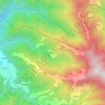
Name: Khatu topographic map, elevation, terrain.
Location: Khatu, Chachyot, Mandi District, Himachal Pradesh, India (31.47651 77.09593 31.51651 77.13593)
Average elevation: 2,474 m
Minimum elevation: 1,894 m
Maximum elevation: 3,159 m
Thank you for supporting this site ❤️
Make a donation
Make a donation
Gear up for your next adventure:
As an Amazon Associate, this site earns from qualifying purchases at no extra cost to you.