
Borgford Lake topographic map
Interactive map
Click on the map to display elevation.
About this map
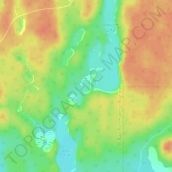
Name: Borgford Lake topographic map, elevation, terrain.
Average elevation: 346 m
Minimum elevation: 322 m
Maximum elevation: 364 m
Other topographic maps
Click on a map to view its topography, its elevation and its terrain.
Painkiller Lake
Canada > Ontario > Cochrane District > Black River-Matheson Township
Painkiller Lake, Black River-Matheson Township, Cochrane District, Northeastern Ontario, Ontario, Canada
Average elevation: 302 m
Wavell
Canada > Ontario > Cochrane District > Black River-Matheson Township
Wavell, Black River-Matheson Township, Cochrane District, Northeastern Ontario, Ontario, Canada
Average elevation: 304 m
Watabeag River
Canada > Ontario > Cochrane District > Black River-Matheson Township
Watabeag River, Black River-Matheson Township, Cochrane District, Northeastern Ontario, Ontario, P0K 1N0, Canada
Average elevation: 261 m