
Make a donation
Gear up for your next adventure:
As an Amazon Associate, this site earns from qualifying purchases at no extra cost to you.
College Park topographic map
Click on the map to display elevation.
Make a donation
Gear up for your next adventure:
As an Amazon Associate, this site earns from qualifying purchases at no extra cost to you.
College Park
College Park features a relatively flat terrain typical of the Atlantic Coastal Plain, with an average elevation of around 100 feet above sea level. The landscape is characterized by gently rolling hills, particularly in the northern and western parts, while lower-lying areas can be found near the various small streams and lakes, such as Lake Artemesia. The area is also notable for its proximity to the Anacostia River watershed, which contributes to the gentle gradients in the region. College Park is dotted with parks and green spaces that enhance the urban environment, providing residents with scenic views and recreational opportunities.
Make a donation
Gear up for your next adventure:
As an Amazon Associate, this site earns from qualifying purchases at no extra cost to you.
About this map
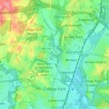
Name: College Park topographic map, elevation, terrain.
Average elevation: 38 m
Minimum elevation: 10 m
Maximum elevation: 100 m
Make a donation
Gear up for your next adventure:
As an Amazon Associate, this site earns from qualifying purchases at no extra cost to you.
Other topographic maps
Click on a map to view its topography, its elevation and its terrain.
Make a donation
Gear up for your next adventure:
As an Amazon Associate, this site earns from qualifying purchases at no extra cost to you.
Make a donation
Gear up for your next adventure:
As an Amazon Associate, this site earns from qualifying purchases at no extra cost to you.
Sellman Estates
United States > Maryland > Prince George's County > Beltsville
Average elevation: 61 m
Make a donation
Gear up for your next adventure:
As an Amazon Associate, this site earns from qualifying purchases at no extra cost to you.
Make a donation
Gear up for your next adventure:
As an Amazon Associate, this site earns from qualifying purchases at no extra cost to you.
Mount Rainier Neighborhood Park
United States > Maryland > Prince George's County > Mount Rainier
Average elevation: 21 m
Farmington Road Estates
United States > Maryland > Prince George's County > Farmington Road Estates
Average elevation: 47 m
Make a donation
Gear up for your next adventure:
As an Amazon Associate, this site earns from qualifying purchases at no extra cost to you.