
Punjab topographic map
Interactive map
Click on the map to display elevation.
About this map
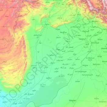
Name: Punjab topographic map, elevation, terrain.
Location: Punjab, Pakistan (27.70555 69.26176 34.01876 75.38148)
Average elevation: 623 m
Minimum elevation: 53 m
Maximum elevation: 5,045 m
Punjab's landscape consists mostly consists of fertile alluvial plains of the Indus River and its four major tributaries in Pakistan, the Jhelum, Chenab, Ravi, and Sutlej rivers which traverse Punjab north to south – the fifth of the "five waters" of Punjab, the Beas River, lies exclusively in the Indian state of Punjab. The landscape is amongst the most heavily irrigated on earth and canals can be found throughout the province. Punjab also includes several mountainous regions, including the Sulaiman Mountains in the southwest part of the province, the Margalla Hills in the north near Islamabad, and the Salt Range which divides the most northerly portion of Punjab, the Pothohar Plateau, from the rest of the province. Sparse deserts can be found in southern Punjab near the border with Rajasthan and near the Sulaiman Range. Punjab also contains part of the Thal and Cholistan deserts. In the South, Punjab's elevation reaches 2,327 metres (7,635 ft) near the hill station of Fort Munro in Dera Ghazi Khan.
Other topographic maps
Click on a map to view its topography, its elevation and its terrain.
Faisalabad City Tehsil
Faisalabad City Tehsil, Faisalabad District, Punjab, Pakistan
Average elevation: 185 m
Tutt
Pakistan > Khyber Pakhtunkhwa > Battagram District > Allai Tehsil
Tutt, Allai Tehsil, Battagram District, Hazara Division, Khyber Pakhtunkhwa, Pakistan
Average elevation: 2,231 m
Khudian Khas
Pakistan > Punjab > Kasur District
Khudian Khas, Kasur Tehsil, Kasur District, Lahore Division, Punjab, Pakistan
Average elevation: 192 m
Banglore Town
Pakistan > Sindh > Karachi Division > Gulshan-e-Iqbal Town
Banglore Town, Bahadurabad, Gulshan-e-Iqbal Town, Karachi East District, Karachi Division, Sindh, 75300, Pakistan
Average elevation: 20 m
Sibi
Pakistan > Balochistan > Sibi District
Sibi, Sibi Tehsil, Sibi District, Balochistan, 82000, Pakistan
Average elevation: 170 m
Harnai
Pakistan > Balochistan > Harnai District
Harnai, Harnai Tehsil, Harnai District, Balochistan, 82300, Pakistan
Average elevation: 966 m
Mouza Kund
Pakistan > Balochistan > Hub District
Mouza Kund, Gadani Tehsil, Hub District, Qalat Division, Balochistan, Pakistan
Average elevation: 6 m
Gadap Town
Pakistan > Sindh > Karāchi District > Karachi Division
Gadap Town, Malir District, Karachi Division, Karāchi District, Sindh, Pakistan
Average elevation: 176 m
Kharfaq
Kharfaq, Ghanche District, Gilgit-Baltistan, Pakistan
Average elevation: 2,917 m
Lahore District
Lahore District, Lahore Division, Punjab, Pakistan
Average elevation: 213 m
Kot Duni Chand
Kot Duni Chand, Shalimar Tehsil, Lahore District, Lahore Division, Punjab, 54850, Pakistan
Average elevation: 218 m
Zone III
Pakistan > Islamabad Capital Territory
Zone III, Islamabad Capital Territory, Pakistan
Average elevation: 659 m
Nayi Ahbaddi
Pakistan > Azad Kashmir > Mirpur District
Nayi Ahbaddi, Mirpur Tehsil, Mirpur District, Mirpur Division, Azad Kashmir, Pakistan
Average elevation: 243 m
Saddar Town
Pakistan > Sindh > Karachi South District
Saddar Town, Karachi South District, Sindh, Pakistan
Average elevation: 4 m
Mansoora Abad
Mansoora Abad, Faisalabad City Tehsil, Faisalabad District, Punjab, Pakistan
Average elevation: 187 m
Karakoram
Karakoram, Baltistān District, Gilgit-Baltistan, Pakistan
Average elevation: 4,414 m
Gulistan-e-Jauhar
Gulistan-e-Jauhar, Gulshan Town, Sindh, 75300, Pakistan
Average elevation: 37 m
Muzaffargarh
Muzaffargarh, Muzaffargarh Tehsil, Punjab, Pakistan
Average elevation: 121 m
Taho
Taho, Gujrat Tehsil, Bhimber District, Azad Kashmir, Pakistan
Average elevation: 282 m
Taxila
Pakistan > Punjab > Taxila Tehsil
Taxila, Taxila Tehsil, Rawalpindi District, Punjab, 47080, Pakistan
Average elevation: 544 m
Nok Kundi
Pakistan > Balochistan > Chagai District
Nok Kundi, Chagai District, Balochistan, Pakistan
Average elevation: 683 m
K2
K2, ABC to Camp 1, Shigar District, Gilgit-Baltistan, Pakistan
Average elevation: 7,490 m
Khunjerab Pass
Khunjerab Pass, Gilgit-Baltistan, Pakistan
Average elevation: 4,771 m
Saro Kaly
Pakistan > Khyber Pakhtunkhwa > Saro Kaly
Saro Kaly, Khyber Pakhtunkhwa, Pakistan
Average elevation: 348 m
Skardu
Pakistan > Gilgit-Baltistan > Skardu
Skardu, Gilgit-Baltistan, BALTISTAN, Pakistan
Average elevation: 3,486 m
Westridge
Pakistan > Rawalpindi Cantonment > Westridge > Westridge
Westridge, Rawalpindi District, Rawalpindi Cantonment, Punjab, RC8 6AF, Pakistan
Average elevation: 525 m
Swat
Pakistan > Khyber Pakhtunkhwa > Abazai > Gul Bagh
Swat, Gul Bagh, Abazai, Khyber Pakhtunkhwa, Pakistan
Average elevation: 370 m
Joggin Track Sector A1 Township
Joggin Track Sector A1 Township, Township, Lahore, Lahore District, Punjab, 54700, Pakistan
Average elevation: 214 m
Sirikot
Pakistan > Khyber Pakhtunkhwa > Sirikot
Sirikot, Khyber Pakhtunkhwa, 22840, Pakistan
Average elevation: 882 m
Former Chitrāl District
Former Chitrāl District, Khyber Pakhtunkhwa, Pakistan
Average elevation: 3,729 m