
Civitella d'Arna topographic map
Interactive map
Click on the map to display elevation.
About this map
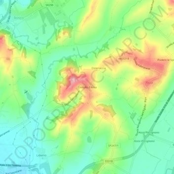
Name: Civitella d'Arna topographic map, elevation, terrain.
Location: Civitella d'Arna, Perugia, Umbria, 06134, Italy (43.10661 12.46991 43.14661 12.50991)
Average elevation: 242 m
Minimum elevation: 185 m
Maximum elevation: 336 m
Other topographic maps
Click on a map to view its topography, its elevation and its terrain.
Fratticiola Selvatica
Italy > Umbria > Perugia > Perugia
Fratticiola Selvatica, Perugia, Umbria, Italy
Average elevation: 503 m
Ponte Felcino
Italy > Umbria > Perugia > Perugia > Ponte Felcino
Ponte Felcino, Perugia, Umbria, 06080, Italy
Average elevation: 262 m