
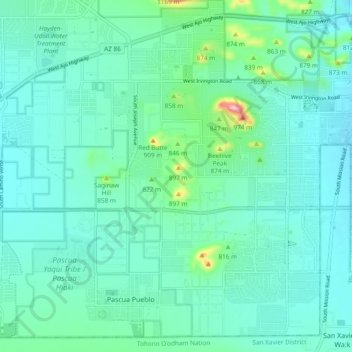
Drexel Heights topographic map
Interactive map
Click on the map to display elevation.
About this map
Name: Drexel Heights topographic map, elevation, terrain.
Average elevation: 786 m
Minimum elevation: 747 m
Maximum elevation: 984 m
The area has numerous Saguaro cacti, and is positioned only a couple of miles south of the Saguaro National Park. The northern boundary of Drexel Heights is the Tucson Mountain Park. It is cut off from the rest of Tucson due to the topography of the Tucson Mountains, which are only crossed via a small number of roads: Ajo Highway is the main crossing, with Gates Pass providing a more scenic route. Coyotes and Javalinas are commonly sighted in the area.
Other topographic maps
Click on a map to view its topography, its elevation and its terrain.
Tucson
United States > Arizona > Pima County > Tucson
Tucson, Pima County, Arizona, 85701, United States
Average elevation: 836 m
Agua Caliente Wash
United States > Arizona > Pima County > Tucson
Agua Caliente Wash, Powder Horn Ranch, Tucson, Pima County, Arizona, United States
Average elevation: 791 m
Catalina Foothills
United States > Arizona > Pima County > Tucson
Catalina Foothills, Tucson, Pima County, Arizona, United States
Average elevation: 949 m
Mitchell Park
United States > Arizona > Pima County > Tucson
Mitchell Park, Mountain 1st Avenue, Tucson, Pima County, Arizona, United States
Average elevation: 731 m
Iron Horse
United States > Arizona > Pima County > Tucson
Iron Horse, Tucson, Pima County, Arizona, United States
Average elevation: 736 m
Archer Lake
United States > Arizona > Pima County > Tucson
Archer Lake, Tucson, Pima County, Arizona, United States
Average elevation: 695 m
Rillito River
United States > Arizona > Pima County > Tucson
Rillito River, Tucson, Pima County, Arizona, United States
Average elevation: 790 m