
Make a donation
Gear up for your next adventure:
As an Amazon Associate, this site earns from qualifying purchases at no extra cost to you.
Shimla topographic map
Click on the map to display elevation.
Make a donation
Gear up for your next adventure:
As an Amazon Associate, this site earns from qualifying purchases at no extra cost to you.
Shimla
Shimla is on the south-western ranges of the Himalayas at 31°37′N 77°06′E / 31.61°N 77.10°E / 31.61; 77.10. It has an average altitude of 2,206 metres (7,238 ft) above mean sea level and extends along a ridge with seven spurs. The city stretches nearly 9.2 kilometres (5.7 mi) from east to west.
Make a donation
Gear up for your next adventure:
As an Amazon Associate, this site earns from qualifying purchases at no extra cost to you.
About this map
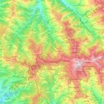
Name: Shimla topographic map, elevation, terrain.
Location: Shimla, Himachal Pradesh, India (31.06418 77.11730 31.16034 77.22992)
Average elevation: 1,826 m
Minimum elevation: 1,276 m
Maximum elevation: 2,439 m
Make a donation
Gear up for your next adventure:
As an Amazon Associate, this site earns from qualifying purchases at no extra cost to you.
Other topographic maps
Click on a map to view its topography, its elevation and its terrain.
Dharamshala
India > Himachal Pradesh > Dharamshala
The town is located in the Kangra Valley, in the shadow of the Dhauladhar range of the Himalayas at an altitude of 1,457 metres (4,780 ft). References to Dharamshala and its surrounding areas are found in ancient Hindu scriptures such as Rig Veda and Mahabharata. The region was under Mughal influence before it…
Average elevation: 1,781 m
Make a donation
Gear up for your next adventure:
As an Amazon Associate, this site earns from qualifying purchases at no extra cost to you.
Make a donation
Gear up for your next adventure:
As an Amazon Associate, this site earns from qualifying purchases at no extra cost to you.