
North Baddesley topographic map
Click on the map to display elevation.
About this map
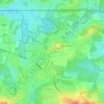
Name: North Baddesley topographic map, elevation, terrain.
Average elevation: 42 m
Minimum elevation: 24 m
Maximum elevation: 78 m
Other topographic maps
Click on a map to view its topography, its elevation and its terrain.
News Wood
United Kingdom > England > Hampshire > Test Valley > King's Somborne
Average elevation: 93 m
Bath Meadows
United Kingdom > England > Hampshire > Test Valley > Wellow > East Wellow
Average elevation: 30 m
Bitterne Grove
United Kingdom > England > Hampshire > Test Valley > Mottisfont > Dunbridge
Average elevation: 39 m
Canada Common
United Kingdom > England > Hampshire > Test Valley > Wellow > Canada
Average elevation: 39 m
Charlton Down
United Kingdom > England > Hampshire > Test Valley > Wildhern > Charlton Down
Average elevation: 111 m
Rockmoor Pond
United Kingdom > England > Hampshire > Test Valley > Littledown
Average elevation: 208 m
The Bog
United Kingdom > England > Hampshire > Test Valley > Braishfield > Crookhill
Average elevation: 39 m
Hazel Wood
United Kingdom > England > Hampshire > Test Valley > Wellow > Wellow Wood
Average elevation: 37 m