
Anger topographic map
Interactive map
Click on the map to display elevation.
About this map
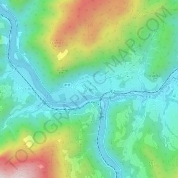
Name: Anger topographic map, elevation, terrain.
Average elevation: 627 m
Minimum elevation: 371 m
Maximum elevation: 1,240 m
Other topographic maps
Click on a map to view its topography, its elevation and its terrain.
Ternberg
Österreich > Oberösterreich > Bezirk Steyr-Land
Ternberg, Bezirk Steyr-Land, Oberösterreich, 4452, Österreich
Average elevation: 618 m
Haagen
Österreich > Oberösterreich > Bezirk Steyr-Land > Aschach an der Steyr
Haagen, Aschach an der Steyr, Bezirk Steyr-Land, Oberösterreich, 4421, Österreich
Average elevation: 447 m
Plattenberg
Österreich > Oberösterreich > Bezirk Steyr-Land > Laussa
Plattenberg, Laussa, Bezirk Steyr-Land, Oberösterreich, 4461, Österreich
Average elevation: 724 m
Sierning
Österreich > Oberösterreich > Bezirk Steyr-Land
Sierning, Bezirk Steyr-Land, Oberösterreich, 4522, Österreich
Average elevation: 387 m