
Town of Rochester topographic map
Interactive map
Click on the map to display elevation.
About this map
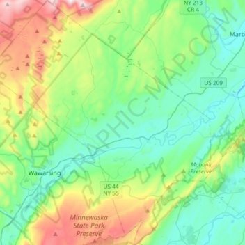
Name: Town of Rochester topographic map, elevation, terrain.
Location: Town of Rochester, Ulster County, New York, United States (41.69410 -74.42741 41.91389 -74.15695)
Average elevation: 261 m
Minimum elevation: 34 m
Maximum elevation: 894 m
Other topographic maps
Click on a map to view its topography, its elevation and its terrain.
Tillson
United States > New York > Ulster County > Town of Rosendale
Tillson, Town of Rosendale, Ulster County, New York, 12486, United States
Average elevation: 58 m
Bloomington
United States > New York > Ulster County > Town of Rosendale
Bloomington, Town of Rosendale, Ulster County, New York, 12411, United States
Average elevation: 61 m
City of Kingston
United States > New York > Ulster County
City of Kingston, Ulster County, New York, 12401, United States
Average elevation: 52 m
Town of Woodstock
United States > New York > Ulster County
Town of Woodstock, Ulster County, New York, United States
Average elevation: 332 m
Town of Olive
United States > New York > Ulster County
Town of Olive, Ulster County, New York, United States
Average elevation: 344 m