
Yoho National Park topographic map
Interactive map
Click on the map to display elevation.
Yoho National Park
The weather in the park is localized and changeable. Located on the western side of the continental divide, it receives more precipitation than areas east of the divide. Precipitation in the park increases with elevation. In winter, average temperatures are between 5 and −15 °C (41.0 and 5.0 °F) from the months November to April although temperatures can range between 10 and −35 °C (50.0 and −31.0 °F). The coldest weather usually occurs in the months December to February. In summer, mean temperatures average 12.5 °C (54.5 °F) with an average high of 20 °C (68.0 °F) and an average low of 5 °C (41.0 °F). Snowfall and freezing temperatures can occur during the summertime at altitudes above 1,500 m (4,900 ft).
About this map
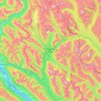
Name: Yoho National Park topographic map, elevation, terrain.
Average elevation: 1,934 m
Minimum elevation: 779 m
Maximum elevation: 3,472 m
Other topographic maps
Click on a map to view its topography, its elevation and its terrain.
Mount Macdonald
Canada > British Columbia > Columbia-Shuswap Regional District > Area A (Kicking Horse/Kinbasket Lake)
Average elevation: 2,019 m
Mount Murray
Canada > British Columbia > Columbia-Shuswap Regional District > Area B (Shelter Bay/Mica Creek)
Average elevation: 1,971 m
Boyd Creek
Canada > British Columbia > Columbia-Shuswap Regional District > Area B (Shelter Bay/Mica Creek)
Average elevation: 1,570 m
McMurdo
Canada > British Columbia > Columbia-Shuswap Regional District > Area A (Kicking Horse/Kinbasket Lake)
Average elevation: 852 m
Mount Cairnes
Canada > British Columbia > Columbia-Shuswap Regional District > Area A (Kicking Horse/Kinbasket Lake)
Average elevation: 2,493 m
Emerald Lake
Canada > British Columbia > Columbia-Shuswap Regional District > Area A (Kicking Horse/Kinbasket Lake)
The lake is enclosed by mountains of the President Range, as well as Mount Burgess and Wapta Mountain. This basin traps storms, causing frequent rain in summer and heavy snowfalls in winter. This influx of moisture works with the lake's low elevation to produce a unique selection of flora. Trees found here are…
Average elevation: 1,413 m
Mount Selwyn
Canada > British Columbia > Columbia-Shuswap Regional District > Area A (Kicking Horse/Kinbasket Lake)
Average elevation: 2,626 m