
South Hummock topographic map
Interactive map
Click on the map to display elevation.
About this map
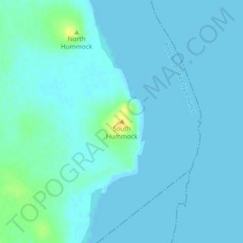
Name: South Hummock topographic map, elevation, terrain.
Average elevation: 4 m
Minimum elevation: -1 m
Maximum elevation: 25 m
Other topographic maps
Click on a map to view its topography, its elevation and its terrain.
Port Augusta
Australia > South Australia > Port Augusta City Council
Port Augusta, Port Augusta City Council, South Australia, 5700, Australia
Average elevation: 9 m
Port Augusta West
Australia > South Australia > Port Augusta City Council
Port Augusta West, Port Augusta City Council, South Australia, 5700, Australia
Average elevation: 16 m