Geolocate

Buffalo Grove topographic map

Click on the map to display elevation.

About this map

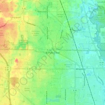
Name: Buffalo Grove topographic map, elevation, terrain.

Location: Buffalo Grove, Wheeling, Wheeling Township, Cook County, Illinois, 60089, United States (42.11141 -87.99979 42.19141 -87.91979)

Average elevation: 210 m

Minimum elevation: 192 m

Maximum elevation: 237 m

Other topographic maps

Click on a map to view its topography, its elevation and its terrain.

Evanston

United States > Illinois > Cook County

Average elevation: 182 m

Wheeling

United States > Illinois > Cook County

Average elevation: 202 m

Chicago Heights

United States > Illinois > Cook County

Average elevation: 203 m

Glencoe

United States > Illinois > Cook County

The village is surrounded on three sides by upper-income communities, with Highland Park on the north, Northbrook on the west, and Winnetka to the south. The Skokie Lagoons are located in the forest preserve to the immediate west of the village. The same forest preserve has a bicycle trail that connects to…

Average elevation: 194 m

Grand Boulevard

United States > Illinois > Cook County > Chicago

Average elevation: 184 m

Dunbar Park

United States > Illinois > Cook County > Chicago

Average elevation: 182 m

Gear up for your next adventure:

Lightweight Tents - Compact tents for backpacking
🥾Hiking Gaiters - Leg protection for trails
🐍Australian Snake Bite Kits - Specific pressure immobilization bandages for Australian venomous snakes
📷Backpack Camera Clips - Quick access to your camera while keeping your hands free for climbing
🍳Ultralight Camping Stoves - Boil water quickly for meals using minimal fuel

As an Amazon Associate, this site earns from qualifying purchases at no extra cost to you.