
Make a donation
Gear up for your next adventure:
As an Amazon Associate, this site earns from qualifying purchases at no extra cost to you.
Wolfeboro topographic map
Click on the map to display elevation.
Make a donation
Gear up for your next adventure:
As an Amazon Associate, this site earns from qualifying purchases at no extra cost to you.
Wolfeboro
According to the United States Census Bureau, the town has a total area of 58.5 square miles (151.4 km2), of which 48.0 square miles (124.2 km2) are land and 10.5 square miles (27.2 km2) are water, comprising 17.95% of the town. Wolfeboro is drained by the Smith River, which is the outlet of Lake Wentworth and an inlet of Lake Winnipesaukee. Via Winnipesaukee, the town is part of the Merrimack River watershed. The highest point in town is Moody Mountain, elevation 1,420 feet (430 m) above sea level, located near the northern boundary.
Make a donation
Gear up for your next adventure:
As an Amazon Associate, this site earns from qualifying purchases at no extra cost to you.
About this map
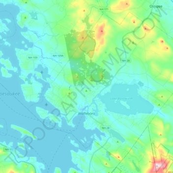
Name: Wolfeboro topographic map, elevation, terrain.
Location: Wolfeboro, Carroll County, New Hampshire, United States (43.53895 -71.28488 43.68028 -71.05920)
Average elevation: 213 m
Minimum elevation: 149 m
Maximum elevation: 555 m
Make a donation
Gear up for your next adventure:
As an Amazon Associate, this site earns from qualifying purchases at no extra cost to you.
Other topographic maps
Click on a map to view its topography, its elevation and its terrain.