
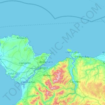
Puffin Island topographic map
Interactive map
Click on the map to display elevation.
About this map
Name: Puffin Island topographic map, elevation, terrain.
Average elevation: 94 m
Minimum elevation: 0 m
Maximum elevation: 1,059 m
Other topographic maps
Click on a map to view its topography, its elevation and its terrain.
South Stack Lighthouse
United Kingdom > Wales > Isle of Anglesey > Trearddur
South Stack Lighthouse, South Stack Road, Trearddur, Isle of Anglesey, Wales, LL65 1YH, United Kingdom
Average elevation: 17 m
Cemaes
United Kingdom > Wales > Isle of Anglesey
Cemaes, Isle of Anglesey, Wales, LL67 0EY, United Kingdom
Average elevation: 20 m
Cefn-bach
United Kingdom > Wales > Isle of Anglesey > Llanddaniel Fab
Cefn-bach, Llanddaniel Fab, Isle of Anglesey, Wales, LL61 6EQ, United Kingdom
Average elevation: 33 m
Holyhead
United Kingdom > Wales > Isle of Anglesey > Holyhead
Holyhead, Isle of Anglesey, Wales, LL65 1UF, United Kingdom
Average elevation: 10 m
Llanfairpwllgwyngyll
United Kingdom > Wales > Isle of Anglesey > Llanfairpwllgwyngyll
Llanfairpwllgwyngyll, Isle of Anglesey, Wales, LL61, United Kingdom
Average elevation: 42 m
Anglesey
United Kingdom > Wales > Isle of Anglesey
Anglesey, Isle of Anglesey, Wales, United Kingdom
Average elevation: 43 m