
Make a donation
Gear up for your next adventure:
As an Amazon Associate, this site earns from qualifying purchases at no extra cost to you.
Praça Cívica topographic map
Click on the map to display elevation.
Make a donation
Gear up for your next adventure:
As an Amazon Associate, this site earns from qualifying purchases at no extra cost to you.
About this map
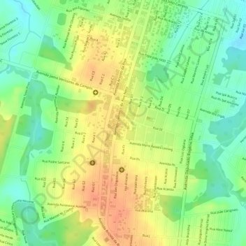
Name: Praça Cívica topographic map, elevation, terrain.
Average elevation: 279 m
Minimum elevation: 255 m
Maximum elevation: 299 m
Make a donation
Gear up for your next adventure:
As an Amazon Associate, this site earns from qualifying purchases at no extra cost to you.
Other topographic maps
Click on a map to view its topography, its elevation and its terrain.
Alta Floresta
Brasil > Mato Grosso > Alta Floresta > Alta Floresta
O município de Alta Floresta possui uma área de 8 947,07 km² e está localizado no extremo norte do estado de Mato Grosso, a 830 km da capital do estado, Cuiabá. Fica a 283 metros de altitude.
Average elevation: 276 m