
Le Cluzeau topographic map
Interactive map
Click on the map to display elevation.
About this map
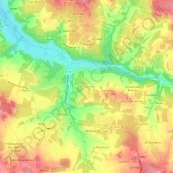
Name: Le Cluzeau topographic map, elevation, terrain.
Average elevation: 106 m
Minimum elevation: 48 m
Maximum elevation: 153 m
Other topographic maps
Click on a map to view its topography, its elevation and its terrain.
Sigoulès
France > Nouvelle-Aquitaine > Dordogne > Sigoulès-et-Flaugeac
L'altitude minimale avec 51 mètres se trouve localisée à l'extrême nord-ouest, près du lieu-dit le Tuquet, là où la Gardonnette quitte la commune et sert de limite entre les territoires de Cunèges et Pomport. L'altitude maximale avec 157 mètres est située à l'ouest, au Pey du Bournat. Sur le plan…
Average elevation: 116 m