
Greenwich topographic map
Interactive map
Click on the map to display elevation.
About this map
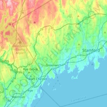
Name: Greenwich topographic map, elevation, terrain.
Average elevation: 57 m
Minimum elevation: -1 m
Maximum elevation: 224 m
Other topographic maps
Click on a map to view its topography, its elevation and its terrain.
Stamford
United States > Connecticut > Western Connecticut Planning Region
Stamford, Western Connecticut Planning Region, Connecticut, United States
Average elevation: 48 m
Ridgefield
United States > Connecticut > Western Connecticut Planning Region
Ridgefield, Western Connecticut Planning Region, Connecticut, 06877, United States
Average elevation: 183 m
Westport
United States > Connecticut > Western Connecticut Planning Region
Westport, Western Connecticut Planning Region, Connecticut, 06880, United States
Average elevation: 22 m
Belltown
United States > Connecticut > Western Connecticut Planning Region > Stamford
Belltown, Stamford, Western Connecticut Planning Region, Connecticut, 06906, United States
Average elevation: 32 m
Palmers Hill
United States > Connecticut > Western Connecticut Planning Region > Stamford
Palmers Hill, Stamford, Western Connecticut Planning Region, Connecticut, 06904, United States
Average elevation: 31 m
Mianus
United States > Connecticut > Western Connecticut Planning Region > Greenwich
Mianus, Greenwich, Western Connecticut Planning Region, Connecticut, 06807, United States
Average elevation: 23 m
North Stamford
United States > Connecticut > Western Connecticut Planning Region > Stamford
North Stamford, Stamford, Western Connecticut Planning Region, Connecticut, 06903, United States
Average elevation: 89 m
Redding
United States > Connecticut > Western Connecticut Planning Region
Redding, Western Connecticut Planning Region, Connecticut, United States
Average elevation: 160 m
Taylor Corners
United States > Connecticut > Western Connecticut Planning Region > New Fairfield
Taylor Corners, New Fairfield, Western Connecticut Planning Region, Connecticut, 06812, United States
Average elevation: 226 m
Bethel
United States > Connecticut > Western Connecticut Planning Region
Bethel, Western Connecticut Planning Region, Connecticut, 06801, United States
Average elevation: 157 m
Beckettville
United States > Connecticut > Western Connecticut Planning Region > Danbury
Beckettville, Danbury, Western Connecticut Planning Region, Connecticut, 06813, United States
Average elevation: 155 m
Contentment Island
United States > Connecticut > Western Connecticut Planning Region > Darien
Contentment Island, Darien, Western Connecticut Planning Region, Connecticut, 06853, United States
Average elevation: 63 m
Norwalk
United States > Connecticut > Western Connecticut Planning Region
Norwalk, Western Connecticut Planning Region, Connecticut, United States
Average elevation: 24 m
New Milford
United States > Connecticut > Western Connecticut Planning Region
New Milford, Western Connecticut Planning Region, Connecticut, United States
Average elevation: 193 m
Danbury
United States > Connecticut > Western Connecticut Planning Region
Danbury, Western Connecticut Planning Region, Connecticut, United States
Average elevation: 174 m
New Canaan
United States > Connecticut > Western Connecticut Planning Region
New Canaan, Western Connecticut Planning Region, Connecticut, 06840, United States
Average elevation: 102 m
Honey Hill
United States > Connecticut > Western Connecticut Planning Region > Wilton
Honey Hill, Wilton, Western Connecticut Planning Region, Connecticut, 06829, United States
Average elevation: 126 m
New Fairfield
United States > Connecticut > Western Connecticut Planning Region
New Fairfield, Fairfield County, Connecticut, 06812, United States
Average elevation: 206 m
Danbury
United States > Connecticut > Western Connecticut Planning Region
Danbury, Western Connecticut Planning Region, Connecticut, United States
Average elevation: 174 m
Stamford
United States > Connecticut > Western Connecticut Planning Region
Stamford, Western Connecticut Planning Region, Connecticut, United States
Average elevation: 48 m
Darien
United States > Connecticut > Western Connecticut Planning Region
Darien, Western Connecticut Planning Region, Connecticut, 06820, United States
Average elevation: 12 m
Hunting Ridge
United States > Connecticut > Western Connecticut Planning Region > Stamford
Hunting Ridge, Stamford, Western Connecticut Planning Region, Connecticut, 06903, United States
Average elevation: 81 m
Old Baldy
United States > Connecticut > Western Connecticut Planning Region > Norwalk
Old Baldy, Norwalk, Western Connecticut Planning Region, Connecticut, 06853, United States
Average elevation: 59 m