Geolocate

Melle topographic map

Click on the map to display elevation.

About this map
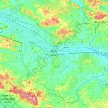
Name: Melle topographic map, elevation, terrain.

Location: Melle, Landkreis Osnabrück, Lower Saxony, Germany (52.10795 8.20305 52.28313 8.51731)

Average elevation: 117 m

Minimum elevation: 64 m

Maximum elevation: 301 m

Other topographic maps

Click on a map to view its topography, its elevation and its terrain.

Borgloh

Germany > Lower Saxony > Landkreis Osnabrück

Average elevation: 127 m

Boberg

Germany > Lower Saxony > Landkreis Osnabrück > Merzen

Average elevation: 104 m

Gear up for your next adventure:

📸Action Cameras - Record your journey across interesting topographic features in 4K
🔪Camping Knives - Multi-purpose outdoor knives
📡Satellite Messengers - Emergency communication devices
🦟Insect Repellent - Protection against insects
🦶Orthotic Hiking Insoles - Extra arch support for long-distance topographic treks

As an Amazon Associate, this site earns from qualifying purchases at no extra cost to you.