Geolocate

Millbrook topographic map

Click on the map to display elevation.

About this map

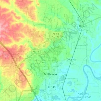
Name: Millbrook topographic map, elevation, terrain.

Location: Millbrook, Elmore County, Alabama, 36054, United States (32.43081 -86.41945 32.57076 -86.32762)

Average elevation: 80 m

Minimum elevation: 37 m

Maximum elevation: 187 m

Gear up for your next adventure:

🧭Global Orienteering Compass - High-precision liquid-filled compasses for accurate map reading and navigation
📖Australian Bush Survival Books - Local knowledge on finding water and surviving the outback
🧼Biodegradable Outdoor Soap - Clean gear and yourself without harming the local ecosystem
📍Handheld GPS - GPS devices for hiking and navigation
🎧Bluetooth Outdoor Earbuds - Listen to navigation cues or podcasts during long solo treks

As an Amazon Associate, this site earns from qualifying purchases at no extra cost to you.