
Thank you for supporting this site ❤️
Make a donation
Make a donation
Gear up for your next adventure:
As an Amazon Associate, this site earns from qualifying purchases at no extra cost to you.
Woolwich topographic map
Click on the map to display elevation.
Thank you for supporting this site ❤️
Make a donation
Make a donation
Gear up for your next adventure:
As an Amazon Associate, this site earns from qualifying purchases at no extra cost to you.
About this map
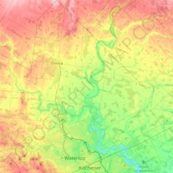
Name: Woolwich topographic map, elevation, terrain.
Location: Woolwich, Region of Waterloo, Ontario, Canada (43.44383 -80.62614 43.68959 -80.30628)
Average elevation: 358 m
Minimum elevation: 289 m
Maximum elevation: 440 m
Thank you for supporting this site ❤️
Make a donation
Make a donation
Gear up for your next adventure:
As an Amazon Associate, this site earns from qualifying purchases at no extra cost to you.
Other topographic maps
Click on a map to view its topography, its elevation and its terrain.
West Montrose
Canada > Ontario > Region of Waterloo > Woolwich > West Montrose
Average elevation: 340 m