Geolocate

Aylmer topographic map

Click on the map to display elevation.

About this map

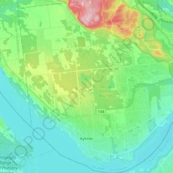
Name: Aylmer topographic map, elevation, terrain.

Location: Aylmer, Gatineau, Outaouais, Quebec, Canada (45.37238 -75.90835 45.48568 -75.75587)

Average elevation: 99 m

Minimum elevation: 46 m

Maximum elevation: 260 m

Other topographic maps

Click on a map to view its topography, its elevation and its terrain.

Pink Lake

Canada > Quebec > Gatineau

Average elevation: 153 m

Parc de la Cité

Canada > Quebec > Gatineau

Average elevation: 58 m

Lac Beauchamp

Canada > Quebec > Gatineau

Average elevation: 56 m

Boisé de l'étrier

Canada > Quebec > Gatineau

Average elevation: 56 m

Gear up for your next adventure:

👣Snake & Scrub Gaiters - Protection against spinifex, mud, and snakes while walking off-track
🔪Outdoor Multi-tools - Versatile tools for gear repair and survival tasks in the wilderness
📷Backpack Camera Clips - Quick access to your camera while keeping your hands free for climbing
🎒Daypacks - Compact backpacks for short hikes
Survival Blankets - Emergency thermal blankets

As an Amazon Associate, this site earns from qualifying purchases at no extra cost to you.