
Make a donation
Gear up for your next adventure:
As an Amazon Associate, this site earns from qualifying purchases at no extra cost to you.
Außig topographic map
Click on the map to display elevation.
Make a donation
Gear up for your next adventure:
As an Amazon Associate, this site earns from qualifying purchases at no extra cost to you.
About this map
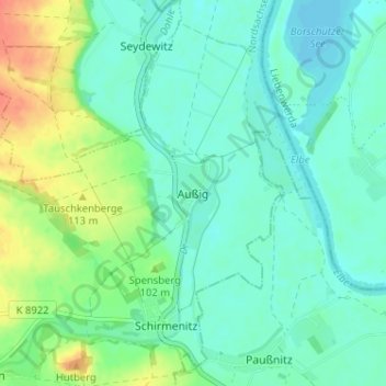
Name: Außig topographic map, elevation, terrain.
Location: Außig, Cavertitz, Nordsachsen, Saxony, Germany (51.38481 13.16994 51.42481 13.20994)
Average elevation: 97 m
Minimum elevation: 84 m
Maximum elevation: 127 m
Make a donation
Gear up for your next adventure:
As an Amazon Associate, this site earns from qualifying purchases at no extra cost to you.
Other topographic maps
Click on a map to view its topography, its elevation and its terrain.
Delitzsch
Germany > Saxony > Nordsachsen
Delitzsch is located in the northwestern part of Nordsachsen in Saxony, at an altitude of 94 meters above sea level. Due to its location on the border with Saxony-Anhalt, Delitzsch is the northernmost town in Saxony. It is situated on the north heath and recreation area Goitzsche which extends across the…
Average elevation: 95 m