
Great Slave Lake topographic map
Interactive map
Click on the map to display elevation.
About this map
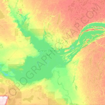
Name: Great Slave Lake topographic map, elevation, terrain.
Location: Great Slave Lake, Northwest Territories, Canada (60.82795 -116.80446 62.95861 -108.89605)
Average elevation: 257 m
Minimum elevation: 149 m
Maximum elevation: 868 m
Other topographic maps
Click on a map to view its topography, its elevation and its terrain.