
Waters topographic map
Click on the map to display elevation.
About this map
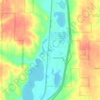
Name: Waters topographic map, elevation, terrain.
Average elevation: 414 m
Minimum elevation: 378 m
Maximum elevation: 454 m
Other topographic maps
Click on a map to view its topography, its elevation and its terrain.
Gaylord
United States > Michigan > Otsego County
Gaylord became a city in 1922. The change from village to city required a vote by town residents. For reasons that are unclear, the margin of passage was a very close 21 votes — 114 people in favor to 93 against. John Hamilton was elected the first mayor of Gaylord. Over the years, the community continued to…
Average elevation: 401 m
Gaylord
United States > Michigan > Otsego County
Gaylord sees significant snowfall during winter due to its elevation and its location in the path of lake-effect snow produced by Lake Michigan. Combined with local terrain and topography, many winter recreation opportunities abound.
Average elevation: 401 m