
Walenstadt topographic map
Interactive map
Click on the map to display elevation.
About this map
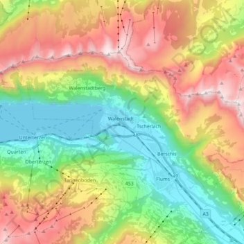
Name: Walenstadt topographic map, elevation, terrain.
Location: Walenstadt, Wahlkreis Sarganserland, Sankt Gallen, Schweiz (47.08758 9.23815 47.15479 9.40934)
Average elevation: 1,213 m
Minimum elevation: 417 m
Maximum elevation: 2,353 m
Trotz der Höhe von Walenstadtberg gibt es vereinzelte Bauernbetriebe. Mehrheitlich ist Walenstadtberg jedoch an den Tourismus gebunden. In Knoblisbühl existiert eine Rehabilitations-Klinik. Ein berühmtes Bauwerk ist das von Karl Bickel errichtete Paxmal. In Walenstadtberg und Knoblisbühl wohnen 192 Personen.