Geolocate

Hasland topographic map

Click on the map to display elevation.

About this map
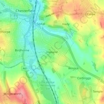
Name: Hasland topographic map, elevation, terrain.

Location: Hasland, Chesterfield, Derbyshire, England, S41 0LN, United Kingdom (53.19929 -1.42933 53.23929 -1.38933)

Average elevation: 107 m

Minimum elevation: 72 m

Maximum elevation: 164 m

Other topographic maps

Click on a map to view its topography, its elevation and its terrain.
Barlow Brook

United Kingdom > England > Derbyshire > Chesterfield > Barlow

Average elevation: 113 m

Tapton Park

United Kingdom > England > Derbyshire > Chesterfield > Tapton

Average elevation: 101 m

Gear up for your next adventure:

🔭Compact Hiking Binoculars - Lightweight optics for scouting routes or birdwatching
🧣Merino Neck Gaiters - Versatile headwear for warmth, sun protection, or dust filtering
🧥Insulated Down Jackets - High warmth-to-weight ratio for cold nights in the high country
🧦Hiking Socks - Comfortable socks for long hikes
🧺Waterproof Dry Sacks - Organize your pack and keep electronics safe from rain and river crossings

As an Amazon Associate, this site earns from qualifying purchases at no extra cost to you.