Geolocate

Jackfield topographic map

Click on the map to display elevation.

About this map

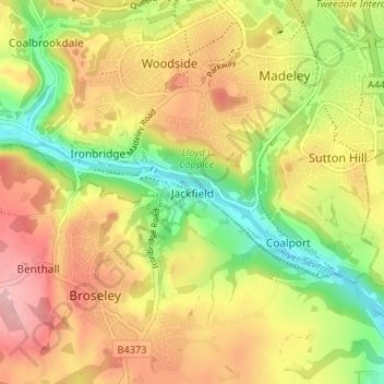
Name: Jackfield topographic map, elevation, terrain.

Location: Jackfield, Telford and Wrekin, England, TF8 7LH, United Kingdom (52.60404 -2.48601 52.64404 -2.44601)

Average elevation: 119 m

Minimum elevation: 37 m

Maximum elevation: 197 m

Other topographic maps

Click on a map to view its topography, its elevation and its terrain.

Madeley

United Kingdom > England > Telford and Wrekin

Average elevation: 116 m

Edgmond

United Kingdom > England > Telford and Wrekin > Edgmond

Average elevation: 73 m

Ketley

United Kingdom > England > Telford and Wrekin > Telford

Average elevation: 127 m

Play Park

United Kingdom > England > Telford and Wrekin > Dawley

Average elevation: 176 m

Madeley

United Kingdom > England > Telford and Wrekin

Average elevation: 116 m

Edgmond

United Kingdom > England > Telford and Wrekin > Edgmond

Average elevation: 73 m

Madeley

United Kingdom > England > Telford and Wrekin

Average elevation: 116 m

Madeley

United Kingdom > England > Telford and Wrekin

Average elevation: 116 m

Gear up for your next adventure:

🔪Outdoor Multi-tools - Versatile tools for gear repair and survival tasks in the wilderness
🧼Clip-on Hand Sanitizer - Maintain hygiene when water for washing is scarce
🛰️Handheld GPS Units - Rugged GPS devices for tracking coordinates and elevation in the Australian bush
📡Portable Emergency Radios - Stay informed about weather warnings and bushfire alerts
🌬️Windbreaker Jackets - Wind protection jackets

As an Amazon Associate, this site earns from qualifying purchases at no extra cost to you.